_no%20fence_LQ.png)
2535 Gerrard St. Shelter
Location: Toronto, Canada
SvN Architects + Planners
Client: City of Toronto
Homeless Shelter
*the shelter design is not finalized and meant to be shared strictly as an example of work.
The shelter at 2535 Gerrard St. E. will serve approximately 80 adults of all genders, including couples, and will be purpose-built to meet the needs of clients and integrate into the surrounding community.
All shelter sites are staffed 24-hours a day, seven days a week and offer outcome-focused supports to help clients improve their well-being and stabilize their lives.
Services will include:
-
Meals and laundry
-
Counsellors/case managers who work with clients to develop permanent housing plans
-
Access to harm reduction, physical and mental health care supports
-
Recreation and social programming
-
Assessments and referrals to other community services as needed
-
Pet supports, to ensure pets and owners can stay together
.png)
-01_edited.jpg)


Thorncliffe Park TOC Masterplan
The Ontario Line
Location: Toronto, Canada
SvN Architects + Planners (Ontario Line Technical Advisory Team)
Transit-oriented development
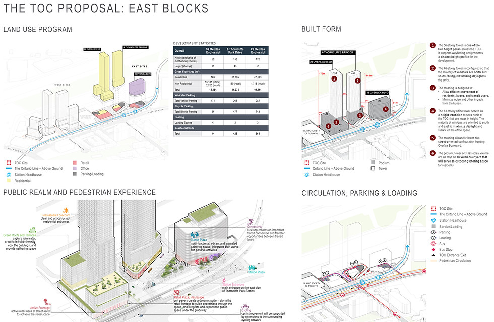
The TOC is situated across four blocks on the north side of Overlea Boulevard, roughly between Millwood Drive and directly east of Beth Nealson Drive. The TOC consists of five sites, with tower heights ranging from 13 - 56 storeys, and podium heights ranging from eight - 12 storeys. The height distribution maximizes sunlight onto the public realm and creates two height peaks, with pedestrian oriented building massings that frame the public realm. The sites are divided by the onestorey IST.
Overall, the sites are organized by the existing Thorncliffe Park Drive and Overlea Boulevard and the proposed extension of Leaside Park Drive north of Overlea Boulevard. The site plan is informed by the public spaces, including the public park that is sited in the westernmost block to maximize available area, rather than spreading across multiple blocks. The transit plaza and station plaza are located to support the station, and provides easy access for transit users along Overlea Boulevard, while the bus loop is located directly adjacent to the transit station to the east of Thorncliffe Park Drive. Buildings take the form of tall buildings with podiums in order to maximize housing units and employment opportunities within the remaining developable area.


Thorncliffe Park TOC - East Blocks
6 Thorncliffe Park Drive
36 Overlea Boulevard
26 Overlea Boulevard
36 Overlea Boulevard- a 13-storey (51 metre) office tower, directly across from Thorncliffe Park Station. The tower has retail uses at grade that front onto the Transit Plaza, an open space that provides access to the station, bus loop, and 2-6 Thorncliffe Park Drive. There will be three levels of underground parking that will connect to the parking at 6 Thorncliffe Park Drive.
6 Thorncliffe Park Drive- a 46-storey (143 metre) residential tower, integrated within the TTC bus loop, with frontage on both Thorncliffe Park Drive and the Transit Plaza. The tower has retail uses at grade, with an entrance on Thorncliffe Park Drive, along with the residential entrance. The bus loop and adjacent transit plaza are built above two and half levels of parking that support the TOC.
26 Overlea Boulevard-a 56-storey (172 metre) tower, on top of a U-shaped podium varying from eight-storeys to 12-storeys in height. In the centre, there is an elevated courtyard that will serve as private outdoor amenity space for residents. The tower has retail uses at grade, with entrances along Overlea Boulevard. The retail entrance is adjacent to a POPS and the station’s emergency exit stairwell. There will be three levels of underground parking.


Thorncliffe Park TOC - West Blocks
14-16 Overlea Boulevard
4-10 Overlea Boulevard
4-10 Overlea Boulevard- a 56-storey (196.4 metre) and 24-storey (73.3 metre) tower that sit atop an eight-storey podium with townhomes at the base. The Floor Space Index (FSI) is 10.3. This block also has a new 2,565 square metre public park. There will be three levels of underground parking.
14-16 Overlea Boulevard- includes a 31-storey tower (97.4 metres) and 46-storey tower (142.4 metres). The towers sit atop an eight-storey podium, connected via a shared one-storey base. The FSI is 9.6. There is retail space at grade with an entrance on Overlea Boulevard, framed by more POPS and additional public realm under the guideway. There will be three levels of underground parking.


Gerrard-Carlaw South TOC Masterplan
The Ontario Line
Location: Toronto, Canada
SvN Architects + Planners (Ontario Line Technical Advisory Team)
Transit-oriented development
Located south of the primary entrance to Gerrard-Carlaw Station, the site will be developed through the Province of Ontario’s TOC program. It introduces new landmark structures and an enhanced public realm, maintaining its historic role as an economic generator while facilitating the continued growth and evolution of this area as a vibrant, welcoming, transit-oriented, complete community.
The Gerrard-Carlaw South TOC will deliver new transit-supportive housing and employment opportunities, accommodating over 11,900 residents and 3,800 jobs within a Protected Major Transit Station Area.


Gerrard-Carlaw South TOC
Thackeray, Carlaw and Badgerow Blocks
388 Carlaw Avenue
The 388 Carlaw Avenue site is comprised of three blocks:
1. Badgerow block is dedicated to office uses, with a small amount of retail at grade.
2. Carlaw block includes residential uses as well as office space, general commercial space, and a small amount of retail.
3. Thackeray block includes retail on its first floor at grade, with residential uses above.


Gerrard-Carlaw South TOC
Dickens Block
10 Dickens Avenue
Dickens block has a small amount of retail space at grade at the intersection of Thackeray Street and Dickens Street and is otherwise dedicated to residential uses.


Queen Spadina TOC
The Ontario Line
Location: Toronto, Canada
SvN Architects + Planners (Ontario Line Technical Advisory Team)
Transit-oriented development
At Queen-Spadina station, two sites will be developed through the Province of Ontario’s TOC program, introducing new landmark structures through a process of sensitive urban infill. These developments will reflect the rich cultural heritage value and character of Queen Street West and Spadina Avenue and the surrounding neighbourhoods while contributing to the continuing growth of this area as a vibrant complete community.
Located on opposite corners of the Queen-Spadina intersection, the proposed developments will consist of a mix of residential, transit and retail uses, providing primarily new transit-supportive housing options with some employment opportunities. The proposed developments support a mixeduse and transit-oriented community along the Queen Street West corridor, accommodating roughly 375 people and 60 jobs


Queen Spadina North TOC
The Ontario Line
378 Queen Street West,
165–177 Spadina Avenue
On the north site, the existing 3-storey heritage building will be conserved with slight modifications to the facades to facilitate improved accessibility (to be coordinated through a separate heritage review process) and accommodate higher volumes of pedestrian traffic. Above this base, the concept proposes a sculpted addition up to a height of 15 storeys (exclusive of two-storey mechanical/ amenity). This concept draws the primary mass towards the established mid-rise character along Spadina Avenue while reinforcing the character defining low-rise street edge along Queen Street West.


Queen Spadina South TOC
The Ontario Line
443–455 Queen Street West
On the south site, the proposed development consists of a 3-storey base building, containing the station entrance as well as residential and retail spaces, and a residential component up to the height of 14 residential storeys (exclusive of one-storey mechanical/amenity). Technical constraints associated with station construction are anticipated to require the removal of three identified contributing properties (to be coordinated through a separate heritage review process).


110 Adelaide Street East
Location: Toronto, Canada
SvN Architects + Planners
Developer: Windmill
Mixed-use
110 Adelaide East: a proposed 39-storey mixed-use condominium building designed by SvN for Windmill Development Group on the north side of Adelaide Street East west of Jarvis Street, in Toronto's St. Lawrence.
Main contributions include facade and elevations design, and shadow studies for the SPA application.


880 Eastern Avenue
Location: Leslieville, Toronto, Canada
SvN Architects + Planners
Developer: TAS
Mixed-use
Toronto’s first net-zero mid-rise!
Contributed to the Site Plan Application package as well as the production of 100% Design Development submission. Mainly focused on envelope design.
At 880 Eastern Avenue in Leslieville, TAS is creating resilient, purpose-driven, people-centered housing. The project represents a different approach to home building in the city, by putting wellbeing at the centre while also delivering industry-leading carbon reduction strategies.
The new 12-storey building will include 180 new homes with a mix of 1, 2 and 3-bedroom live-work units, with community-serving retail on the ground floor. The project aims to be accessible to a diversity of residents across age, income, family size and ability.
880 Eastern will bring new energy and density to the Leslieville neighbourhood. It’s an example of how a building can be designed to be good for both people and the planet.

Victoria Park - SvN Architects + Planners
Urban Design / Architecture
2022
I was part of the team working on this vision project by SvN to be published as an example of the work we do in building Transit-oriented Communities.
This project focuses on Victoria Park, an above-ground subway station located in an eastern part of Toronto known as Scarborough. The sprawling and underutilized 19-acre subway site includes a surface parking lot where commuters leave their cars for most of the day. A large tower-in-the-park apartment complex lies adjacent to the station with more surface parking and large undefined green areas that keep it disconnected from its surrounding streets. Our proposal also includes the city-operated Dentonia Park Golf Course that connects to an extensive system of open natural spaces along the Taylor-Massey Creek and Danforth Avenue–a key east-west commercial artery that defines the southern edge.
The project focuses on creating a social fabric and public realm connected to the city. Buildings with relatively long and narrow floor plates and organized at different scales will maximize the useability of public space. They will exist in contrast to large and impenetrable commercial podium configurations that typically attract chain stores. This strategy will encourage small-scale businesses, amenities and community programs to occupy ground floor spaces, thereby promoting social interactions and entrepreneurial opportunities unattainable through large podium-style buildings.
New community buildings will animate the site, including a community center over the existing transit station to re-connect the site’s two sides. Other facilities include a daycare with an outdoor playground, a market defined by an outdoor plaza, and an expanded mosque with an adjacent prayer parkette. A landscape approach that emphasizes a “green river” will unify new buildings to the existing neighborhood through a sequence of open spaces that stretch to the site’s southern edge. This landscape provides the community with recreational areas, plazas and community gardens. It also serves as an infrastructure for stormwater management, water filtration systems and maximizing biodiversity on the site.
 Eye-Level-Render-Colourful-1280 |  Vic-Overlay-Existing-1280 |  Vic-Overlay-New-1280 |
|---|---|---|
 PROGRAM-GRADIENT-SAM-1280 |  Site-Plan-11500-01-1280 |  Green-Urban-Rooms-HIGH-RES-01-1280 |
 Floor-plan-Axo-01-1280 |  Groundfloor-Diagram-01-1280 |  Victoria-Park_Section-1280 |


City of Toronto Analysis Maps
Transit Line Proposal
2019
“Under ongoing pressure of unprecedented population growth, the City of Toronto’s built form and housing supply is continually evolving, as evidenced by a profusion of high-rise apartment site infill and mixed-use building development in and along the City’s Centres and Avenues where the City’s Official Plan funnels density. The City’s Official Plan does not currently set low-rise Neighbourhoods as a focus for intensification.” The series of maps below examine the social activity in the city, and then layer it with population increase/decrease as well as existing & proposed transportation lines. The Idea is to propose a transit line based on the analyzed data that serves and connects different neighbourhoods.


Group Selected Transit Line
Don Mills at Lawrence Ave.
The map below shows the proposed transit line based on a number of factors. The line serves the areas where there is a lack in existing and proposed public transit systems, it also creates interchanges with many of those lines. The proposed line connects some neighbourhoods that are having an increase in population and social activities with other neighbourhoods that are struggling, in an attempt to attract development into those areas as well as connect them to known institutions. Lawrence Avenue is also one of the city’s most important east-west corridors. The next step of the exercise was to agree on a proposed transit line with other students and pick a node where transit oriented development can happen. The Station/node I chose to work on was the Lawrence/Don Mills station.


Don Mills is one of the earliest master planned communities in Toronto. I was design to be a complete neighbourhood, that has employment at the edges, apartment blocks and commercial activity near the center that are surrounded by a ring road. The ring road, Lawrence Ave. and Don Mills Rd. divide the site into four quadrants; each of those quadrants contain a community facility and mostly single-family houses.

Don Mills at Lawrence Ave.
Stations & Transit-oriented Development.
Don Mills is one of the earliest master planned communities in Toronto. I was design to be a complete neighbourhood, that has employment at the edges, apartment blocks and commercial activity near the center that are surrounded by a ring road.
The ring road, Lawrence Ave. and Don Mills Rd. divide the site into four quadrants; each of those quadrants contain a community facility and mostly single-family houses.


Dufferin St. from Dundas St. to Queen St. slopes down about 15m as it passes beneath GO Train rails at the south end. The intersections between other major streets and Dufferin St., such as Dundas St., are the main commercial areas, with small shops that bring the street to life, but this liveliness only applies to the streets that intersect with Duffern St., and does not apply to Dufferin itself.

Dufferin Street Revitalization
Rethinking Toronto's un-Avenues
2019
Location: Dufferin St. from Dundas St. to Queen St. Toronto, On.
The project started as a group analysis exercise of Dufferin St. from Dupont st. to Lakeshore. After extensive study, Dufferin st. was divided into segments among the four group members for further study and urban design.
Goals & Objectives: with the lack of housing diversity in Toronto, and the constant demand for new housing it is vital to provide more housing with a good urban environment. Dufferin St. is in deteriorating condition, and lacking the attention it needs, considering its importance as a transportation corridor and its proximity to downtown.
 |  |  |
|---|---|---|
 |  |  |
 |  |  |
 |  |  |
 |  |  |


Al-Kerak Municipality
Governmental Building
2016
Location: AL-Kerak, Jordan
Functions: Offices, Meeting rooms, Cafeteria, Public spaces, tourist facilities and Parking lots.
Importance: The need to create a more user friendly municipality, that demolishes the ideals of dictatorship and formality and allow easy communication between the municipality and the public.
Goals & Objectives: A municipality doing its functions in an interactive, contemporary and transparent way, providing an intermediate space (city plaza) connecting the community to its local government while providing interaction to its different social layers, in an attempt to revive the city, attract tourists and raise awareness to its historical & cultural significance.
Users: Employees, public and tourists.


.jpg)


Reborn Fitness Center
Adaptive Reuse
2014
Adaptive Reuse Project in the residential area of "Lweibdeh" in Amman, Jordan. The chosen new function for the existing apartment building is a fitness center, a facility that is very much needed in that area, with a roof terrace bar which can still function after the fitness center's opening hours.
 elevations |  elevations |  existing 3d |
|---|---|---|
 New 3d |  site plan with existing.jpg |  gf with existing.jpg |
 1st Floor Plan.jpg |  2nd Floor Plan.jpg |  3rd Floor Plan.jpg |
 4th Floor Plan.jpg |  5th floor Plan |  3D SECTION.jpg |
 SECTION 2.jpg |  SECTION 1.jpg |


Hyperolic Reefs:
Biodigital Ecotones
AA Workshop
2016
Biodigital Ecotones is a project that resulted from the Architecture Association Visiting School workshop in Jordan. The workshop focused on defining the ecotones, researching the morphologies and crystallization process of the corals in Aqaba, Jordan at the Red Sea.
The students were asked to develop a connection between ecotones. The project is a group project by: Daniel Elias, Zeinab Sayed Ahmad, and myself. The project experiments with existing landscapes and attempts to create a unique urban experience.
 |  |  |
|---|---|---|
 |  |  |
 |  |  |
 |  |  |
 |  |  |
Disaster Risk Reduction
UN-Habitat Internship
2016
Disaster Risk Reduction or LERMP (Local Emergency and Risk Management Plan) is a joint project between the UN-Habitat Jordan Program and JHRS (Jordan Humanitarian and Resilience Society).
The project mainly involved a study of two vulnerable cities in Jordan; Mafraq and Irbid.
Being part of the UN-Habitat team, I have contributed to the project in cooperation with colleague arch. Reem Hasweh in producing the following maps which present some of the information gathered. this information were intended to become a reference to generate strategies in order to improve the cities’ resilience.